Opwall runs an incredibly diverse range of surveys across our numerous research sites. As such, our science program has become rather complex, and it can be quite hard to keep track of all the different terminology we use to describe the things we do!
We have put this blog post together to provide an “Opwall Dictionary” which aims to provide simple explanations of the different terms you may come across when learning about our research methods.
Acoustics survey – A survey completed using a recording device, rather than directly by a human observer. There are two broad ways in which acoustical surveys can be completed. Either a recording device is held by an observer, or an automated device is used that switches on at a pre-determined time. Acoustical surveys have various advantages over more traditional “manned” surveys (alongside some disadvantages too) and are an approach we will be using increasingly in the future. At the moment acoustics are primarily used to survey birds and bats in Honduras, Mexico, Madagascar, Croatia, and other sites. They are typically deployed in the same locations where we complete our point counts. We also use acoustics to survey freshwater invertebrate diversity at Knepp.

Setting an acoustical recorder in the cloud forests of Cusuco National Park, Honduras. Photo: David Pereira.
Baited remote underwater video (BRUV) – A method in which underwater video cameras are deployed with an attached bait source to attract animals. The bait commonly lures fish, rays & sharks into the camera’s field of view, enabling researchers to record relative abundance of these organisms that are seen infrequently by non-baited methods. This non-invasive approach is particularly valuable in habitats where direct observation is challenging (such as in deep waters) and provides a standardized way to compare the biodiversity of these more elusive species across different sites.
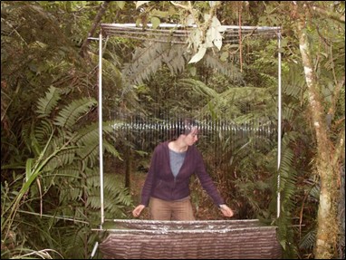
Belt transect – A survey technique that involves systematically examining a fixed-width strip along a predetermined path across a coral reef. Observers record all target organisms within this “belt,” enabling a detailed assessment of the frequency and abundance of specific target species. These are typically conducted by use of a line transect, and searching a certain distance either side of the transect line. Belt transects are especially useful for documenting fine-scale changes in community composition which may be a result of natural disturbances or human impacts on the reef ecosystem.

Survey team completing a belt transect, with a line transect and utilising a length of PVC pipe to determine the width either side of the line transect to be surveyed in Utila, Honduras. Photo: Ashley Kirkham.
Camera trap – A motion-triggered camera placed in locations either associated with transects (for monitoring surveys) or in places where animals are particularly likely to frequent (for behavioural studies – e.g. wallowing sites). Typically (and most frequently) used for large mammals, but can be used for a wide range of taxa. We use camera traps at nearly all of our terrestrial field sites.

A camera-trap deployed and ready for action in Cusuco National Park, Honduras. Photo: Larissa Barker
DISTANCE analysis – A fairly complex statistical approach we use to determine wildlife population sizes based on data obtained from line transects or point counts. Essentially, (and in very simple terms) DISTANCE can estimate the population size of a given species if you know how detectable a species is and how this detectability decreases with distance from the observer. This information, combined with data on the number of individuals seen during surveys and how far away these individuals are from the observer, can be fed into a model that will give overall population size estimates. DISTANCE analysis is therefore the reason why you will often be asked to estimate distance and angle of animals you spot on our transects! This is approach is most commonly used for estimating population sizes of large mammals (for example, in Mexico, South Africa, or Madagascar), although it can be used for a wide range of taxonomic groups.

Determining how far away a Giraffe on a line transect is. Photo: Danielle Hines
Habitat plot – A study area of a fixed size (typically 20m x 20m) in which a range of habitat variables are measured. Habitat plots are typically located at set intervals along transects, often in the same place where certain biodiversity surveys (bird point counts, pollard counts, etc) so habitat data can be directly correlated with this biodiversity data. Variables measured in a habitat plot include canopy density, tree size, understorey density, and carbon stocks (in forest ecosystems) or grass height and volume, vegetation cover, and presence of indicator plant species (in grassland habitats). Habitat plots are often considered our most important surveys, as data from these helps us to make sense of any observed changes in biodiversity patterns revealed by our other surveys. They are completed at all of our terrestrial research sites.

Setting out a rainforest habitat plot. Photo: Alex O’Brien
Harp trap – A fairly specialized way of catching bats, used for species which are good at avoiding mist nets. Harp traps consist of a metal frame which supports two to four rows of vertical strings, and with a large collecting bag at the bottom. Echolocating bats (which can be good at spotting and avoiding mist-nets) find it hard to observe the strings of a harp trap, and on colliding with them will fall safely into the catch bag, where they can be extracted by a qualified bat scientist. Harp traps are not used frequently by Opwall, but can be seen in action at our Croatia site.
A harp trap being made ready for action.
Habitat assessment Score (HAS) – A standardized metric used to evaluate coral reef health by quantifying key habitat parameters such as coral cover, structural complexity (rugosity), and substrate composition. Each parameter is scored and combined into a single value, allowing for direct comparisons between reef sites and tracking of changes over time. These surveys are typically conducted over a series of quadrats.

Habitat Assessment Score (HAS) survey method for coral reef environments.
Light trap – A specialised trap designed to attract nocturnal insects – principally moths, but also other taxa such as Jewel Scarab and Longhorn beetles. A light trap essentially consists of an extremely bright bulb either placed inside a bucket-like trap or directly behind a large canvas sheet. For the former method, the trap is left out overnight and checked for captures in the morning. For the latter method, the trap is observed by entomologists during set survey hours, and any target taxa that land on the canvas sheet are collected by hand. Bucket-trap light trapping is completed at Knepp, while canvas sheet-style light trapping is completed in Honduras.

Canvas sheet-style light trapping in the cloud forests of Cusuco National Park. Photo: Danielle Gilroy.
Line transect – One of the two main ways of collecting data on a transect (the other being the use of survey sites). On a line transect, the entire transect is the sampling area. Terrestrial surveys using a line transect methodology include patch occupancy and distance sampling surveys for mammals, visual encounter surveys for herpetofauna and pollard walks for butterflies. On our marine sites they are used for point intercept transects (PIT), Stereo Video Surveys (SVS) and belt transects. So in these cases, instead of looking for mammals or reptiles within a set survey plot, any animal encountered on the transect would be used for data analysis. Forms of line transect are used at all of our research sites.

Laying out a line transect in the coral reefs of Utila, Honduras. Photo: Matt Bassett.
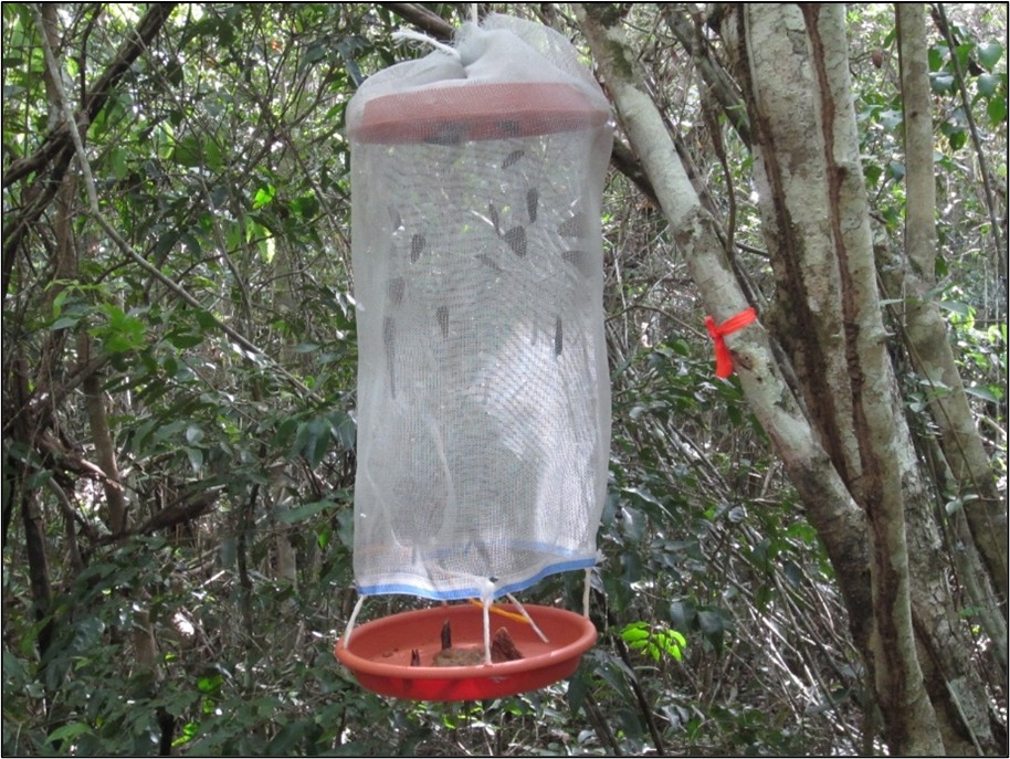
Malaise trap – A tent-like structure used for trapping flying insects. Insects fly into the trap and then fly upwards towards the highest point, where a jar of killing agent is placed. The traps are regularly visited by a member of the entomology team who removes specimens and maintains the trap. Malaise traps within the Opwall research program are generally focussed towards sampling flies (Diptera) and are used in Honduras, Knepp, and (at times) other sites.

A Malaise trap at Knepp, UK, primed and ready for action. Photo: Helen Clark.
Mist-net – A specialized means of capturing birds and bats. Mist-nets are fine mesh nets of variable length, but are usually >10m long and 2.6m high. They are typically set either at survey sites or at specialist netting areas called constant effort sites. Mist-netting takes place either early in the morning (for birds) or between dusk and midnight (for bats). A bird or bat flying into the net becomes entangled, and can be safely extracted by a skilled ornithologist/bat scientist during regular net checks. Once extracted, measurements can be taken, and a ring placed on the bat/birds leg to allow for mark-release-recapture analysis (as well as to provide useful demographic data). Note that some bats can detect mist-nets with their echolocation and easily avoid them – for these species harp traps should be used. Mist-netting is completed in all of our terrestrial research sites.

Setting a mist-net in the forests of Calakmul, Mexico. Photo: Henry Ball.
Monitoring survey – A monitoring survey involves completing the same survey in exactly the same way, in the same place, year after year, in order to detect any changes in biodiversity of the environment. Keeping monitoring methods identical between years is vital to ensure any observed changes are real, and not due to survey bias. The great majority of methods described in this dictionary are varieties of monitoring surveys.
Non-baited remote underwater video – A video-based survey method in which underwater cameras are deployed on coral reefs without any attractants. This approach typically has a focal area or species on the reef itself, and is used to capture natural behaviours and interactions between species. We commonly use them for assessing the behaviour of anemone-associated fish species, and cleaning stations! Non-baited surveys are ideal for monitoring small scale species interactions, free from the potential behavioural biases induced by bait or the presence of divers.

Non-baited underwater camera set up recording a coral bommie to investigate interactions between the resident species in Indonesia. Photo: Benjamin Titus
Patch occupancy survey – A form of line transect, typically used for large and medium-sized mammals, but can also be used for other taxonomic groups. Typically, DISTANCE-sampling is the most effective way of determining the population size of large mammals in a given ecosystem as this allows for the calculation of a specific quantitative estimate. However, this approach relies on being able to directly observe animals in the field – not always easy in many ecosystems, especially in tropical forests. In these cases, patch occupancy surveys are used. This involves slowly walking an entire transect and searching carefully for indirect animal signs – e.g. tracks and prints – along its length. Direct sightings of animals can also be used, but these tend to be more rare in the habitats where patch occupancy is used. Transects are broken up into ‘patches’ of equal length (e.g. 50m) and all the observer needs to record is whether there is evidence of given species ‘occupying’ each patch (e.g. “yes” or “not”) during the survey. Patch occupancy cannot be used to estimate population size directly, but it can provide information on whether a given species is occupying more or less habitat than it used to, if these surveys are completed as part of a monitoring program. Patch occupancy surveys are used at most of our terrestrial research sites.
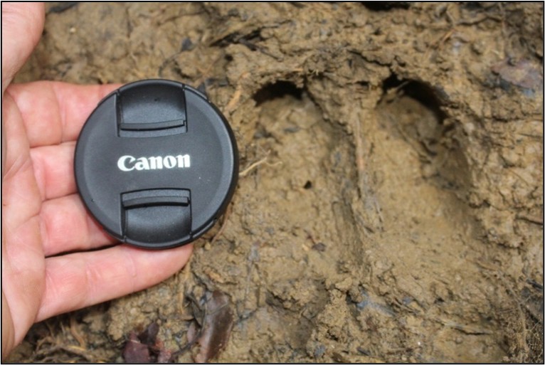
An Anoa footprint found on a patch occupancy survey on Buton Island, Indonesia.
Pitfall trap – A form of trap that can take two forms; “big” pitfall traps for vertebrates, and “small” pitfall traps for invertebrates. Big pitfall traps are primarily used to survey herpetofauna (reptiles and amphibians), although can also be used to survey small mammals. They consist of large buckets dug into the ground, connected by a line of drift-fencing which directs any animals attempting to cross the pitfall line towards the buckets. Any animals falling into the buckets are unable to escape, and can be retrieved, identified, measured, and released by the scientist running the survey. These pitfall traps must be checked a minimum of once daily. “Small” pitfall traps targeting invertebrates typically consist of a plastic cup filled with a small amount of killing agent. Any insects that fall into them are killed, and collected later by an entomologist as specimens. These pitfall traps are often baited with something that will attract the species the entomologist is interested in – e.g. balls of rolled dung for dung beetles. “Large” pitfall traps are used at our field site in Indonesia, while “small” pitfall traps are used in Honduras.

A line of pitfall traps, connected with a drift fence, in the forests of Buton Island, Indonesia. Photo: Ariel Amir.
Point count – A survey type completed at study sites. Point counts involve staying in a stationary position at the centre of the study site and recording everything seen and heard (often within a fixed radius) within a fixed time period (typically ten minutes). Point counts differ from timed searches in that observers remain stationary and complete the survey passively, rather than actively searching for target species. Point counts are most frequently used for birds (and usually require quite a high skill level, as most birds need to be recorded by sound rather than sight, especially in forest ecosystems), although we also use them occasionally for other survey types. Point counts are used in nearly all our terrestrial research sites.

Students completing a point count on Buton Island, Indonesia.
Pollard walk – A particular kind of butterfly survey that combines elements of both line transects and timed search. Pollard walks take place along transects, with a team of scientists and students equipped with seine nets walking the route slowly and catching and identifying butterflies as they encounter them (as with a line transect). However, the butterfly team also stops at a series of survey sites along the transect (usually the same location as the habitat plots), completed a ten-minute timed search where all butterflies within a radius of the plots central point are caught and identified. Pollard walks are completed in several sites, including Croatia, Romania, and Indonesia.

Completing a Pollard count in the tropical forests of Buton Island. Photo: Lupi Yulian.
Quadrat – A square sampling area of variable size marked out with tape or a metal square. They are used to mark out a specific area in which individual organisms are counted or percentage cover of target variables are estimated. Quadrats are widely used in both terrestrial and marine surveys. In terrestrial sites they are most frequently used as a component of habitat plots, for example measuring out a smaller area of the plot in which counts of saplings and seeding can be completed. In marine sites they are often incorporated into line transects and used to estimate variables of key benthic components such as coral or algal cover.
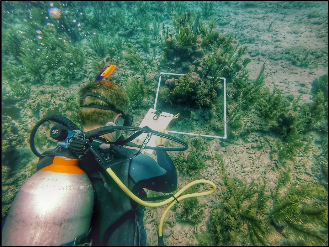
Marine scientists using a quadrat to estimate benthic vegetation cover off Akumal, Mexico. Photo: Barney Smith.
Photogrammetry – A technique that uses overlapping photographs to create three-dimensional models of coral reef structures. In coral reef monitoring, photogrammetry is employed to precisely measure coral cover, reef rugosity (complexity of the structure), and structural changes between sites. The size of these can vary greatly, from 1x1m quadrats to 50x5m line transects. This method supports detailed spatial analysis and long-term tracking of reef degradation or recovery following disturbances such as bleaching events or storms as it forms a snapshot of the reef which is kept as a permanent record to be compared over time.

Diver filming the reef with a photogrammetry rig, consisting of three GoPro cameras to create a 3D model of the reef in Utila, Honduras. Photo: Ashley Kirkham
Point intercept transect – A sampling method where observers record the presence or absence of specific benthic components (coral species, algae, and substrate types) at predetermined points along a line transect across a reef. At each predetermined point, the reef component at each “intercept” (typically every 25cm) is recorded to provide quick, systematic estimates of cover and composition of the reef. This method is particularly effective for long-term monitoring and assessment of coral ecosystem health.
Sherman trap – A rectangular metal trap used to capture small mammals. Sherman traps (and the similar longworth traps, which we also use) work by the activation of a metal touch-plate. Traps are baited with a ball of rodent food (often a mix of oats and peanut butter), filled with some animal bedding, and left out overnight. Any small mammals investigating the smell of the food and entering the trap will trigger the touch-plate and cause the door of the trap to shut behind them, trapping them. The traps are then checked in the morning, with any small mammal captures being identified, measured, marked (for mark-release-recapture studies) and then released. Sherman traps are used at our research sites in Honduras and at Knepp.

A Sherman trap being prepared for use. Photo: Tom Martin.
Survey site – Fixed study areas located at regular intervals along a transect. Study sites are a critical part of our monitoring strategy, being surveyed every year. Surveys that take place on survey sites include habitat plots, bird point counts, mist netting surveys, fungi timed searches, herpetofauna pitfall traps, and pollard counts. Having multiple surveys taking place at the same survey sites means we can correlate biodiversity data from different taxa with each other, and also use habitat data to explain these changes. The schematic in the “transect” section of this dictionary shows how survey sites are integrated with transects. All of our research sites use study sites.
Stereo-video survey – This is a video-based approach to completing underwater biodiversity surveys on the fish communities and biomass estimations and was pioneered by Opwall and our collaborators. Stereo-video surveys use a rig that consists of two video cameras attached to a specialised frame. They are used across a line transect, although instead of the observer trying to count fish (and other species) in the water, we simply switch the cameras on and film the length of the transect. The recording is then analyzed on a computer post-survey, where we synchronise the cameras and then identify all the fish species we see. Having two cameras allows us to actually measure the fish too, giving us estimations of the biomass of each fish! This is a much more effective means of obtaining data on fish communities than the notoriously error-prone historic approaches of trying to identify and estimate lengths in-situ!

Completing a stereo-video survey over the coral reefs of Hoga, Indonesia. Photo: Kuyer Fazekas Jr.
Timed search – A survey type whereby a team of scientists search a survey site intensively for a particular taxa for a set period of time (typically 10 minutes). They differ from point counts in that they are more active, involving physically searching the environment and capturing organisms. Timed searches are used for a variety of taxa, including fungi in Honduras, butterflies as part of pollard count methodologies in Croatia, and herpetofauna in Indonesia.

Finding fungi specimens during a timed search in the cloud forests of Cusuco National Park. Photo: Alex O’Brien
Transect – A fixed route on which we complete our standardized monitoring surveys each year. Alternative names sometimes used include sampling routes or survey paths. Transects are often straight lines (especially in marine sites) although can wind quite a lot in locations where its hard to find a safe, accessible straight route (as is often the case in tropical ecosystems). They range from several kilometers long (in terrestrial sites) to 10m or less (for some marine surveys). Transects can be used for line transect sampling, and also typically have survey sites placed at regular intervals along their length which support other survey types, such as habitat plots, point counts, and timed searches.

Schematic of transect design in the forests of Calakmul, Mexico, Each 2km transect has five survey sites located along its length at 400m intervals.
Van Someren-Rydon trap – A trap designed to capture fruit-feeding butterflies. It consists of a cylinder of netting that is anchored at the top and open at the bottom by solid platforms (usually plastic plates or a similar material). The traps are hoisted off the ground by a pulley system (sometimes quite high into the canopy). Bait (fermented fruit) is placed on the bottom platform. Butterflies attracted to the bait land on the lower platform, and when they take off they fly upwards, into the cylinder of netting, from which they cannot escape. The entomology team regularly check the nets, identifying and releasing any butterflies caught. Van Someren-Rydon traps are typically placed at survey sites and can be found at Mexico site.
A butterfly-filled Van Someren-Rydon trap in Calakmul, Mexico. Photo: Karolina from Clifton College.
Written by Dr Tom Martin – Head of Research & Alex O’Brien – Marine Research and Operations Manager


© 2026 Operation Wallacea Ltd. Website by Yello Media.
Social Media Links